MACROscope
About the Macroscope
My name is Mike Hamilton, and I've had a long history of tinkering with computers, data, and ecological research. This website is a fresh start to experiment with the now vast world of data visualization, ubiquitous remote sensing, and software that can write computer code better than I was able to on my own.
I am retired and have a lot of time on my hand to go through my old field and lab notes and come up with new solutions to the many dead ends I encoutered because I wanted the technology to do much more than it was capable of back in the 1980s, 1990s and the 2000s.
I borrowed the name "Macroscope" after being inspired by the 1969 science fiction novel of the same name by Piers Anthony. He conceived of a space-based telescope of infinite resolution in the space-time continuum. I later read a book while in graduate school by a French computer scientist and biologist named Joel de Rosnay. He specialized in systems theory and wrote a book in 1977 called The Macroscope, a new world scientific sysytem. Finally, after a visit to the MIT Media Lab around 1980 (then called the Architects Machine Group) I saw a demo of a interactive multimedia system called the Aspen Movie Map, which linked a large computer called a VAX, with a programmable laserdisc player. The potential for this seems endless and I made it a goal to build my own version and call it the Macroscope.
Here is a summary of the accomplishments back then, suffice to say these systems have come a long way!
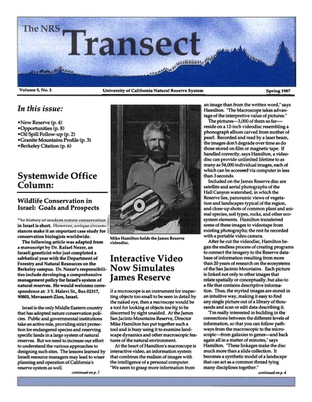
The Macroscope Ecology Laserdisc: An Early Ecological Data Visualization System
Background
The Macroscope project was an innovative endeavor in ecological research and data visualization that began in the late 1980s. Inspired by concepts from science fiction and systems theory, the project aimed to create a comprehensive digital ecosystem for environmental data analysis and exploration.
Project Objectives
The primary goal of the Macroscope was to develop an interactive multimedia system that integrated:
1. Geographic Information Systems (GIS)
2. Remote sensing data (satellite and aerial imagery)
3. 360-degree panoramic habitat visualizations
4. Species databases with high-resolution imagery
5. Natural language AI for ecological expertise emulation
Technical Specifications
Hardware Components
- Apple IIe, Apple Macintosh (first color model) and later PCs
- Programmable laserdisc player
- TEAC laserdisc video recorder (capacity: 54,000 images)
- Canon prototype professional still video camera
Image Acquisition
- 16mm film for panoramic captures (200 images per panorama), 35mm slides transfered as a single video frame, hundreds of analog video camera still for additional ground-based imagery.
- Specialized tripod head for overlapping horizontal and vertical shots
- Image conversion workflow: 16mm film → 1-inch DV videotape → Laserdisc
Software and Database Systems
- FileMaker databases for laserdisc control and metadata management
- Custom XCMDs for video manipulation and interactive features
- QuickTime VR-compatible panorama creation software
Image Specifications
- Resolution: 700 x 500 pixels
- Color depth: 24-bit
Data Integration and Management
The system incorporated multiple data types:
- Satellite imagery
- Aerial photographs
- 360-degree panoramas
- Species close-up images
- Taxonomic information
- Geographic metadata
- Habitat classifications
- Field notes
User Interface and Functionality
The Macroscope interface allowed users to:
1. Navigate virtual guided naturalist walks
2. Explore 360-degree panoramic images
3. Access species identification through an expert system
4. Retrieve precise color values of objects
5. Connect visual data with associated database records
Applications in Environmental Science
The Macroscope project demonstrated potential applications in:
1. Biodiversity assessment and monitoring
2. Ecosystem mapping and classification
3. Species distribution modeling
4. Environmental education and public engagement
5. Remote ecological surveying and data collection
Technological Limitations and Future Perspectives
While groundbreaking for its time, the Macroscope project faced several limitations:
1. High hardware and operational costs
2. Complex setup and maintenance requirements
3. Limited image resolution and storage capacity
4. Restricted portability of the system
However, the project laid the groundwork for modern environmental informatics tools, anticipating developments in:
1. Mobile ecosystem mapping applications
2. High-resolution remote sensing technologies
3. AI-powered species identification systems
4. Virtual reality environmental education platforms
The Macroscope project represents an early attempt to integrate multiple data sources and visualization techniques for comprehensive ecological research and education. Its legacy continues to influence contemporary approaches to environmental data management and analysis.
For additional information about my current projects and activities visit https://animalvegetablerobot.com
I extend my heartfelt gratitude and admiration to the brilliant scientists, engineers, and dedicated professionals at NASA. Their work has inspired countless young minds and continues to impress with its innovation and profound impact on our understanding of the universe and our place within it. And if you want to see what is possible with their idea of a Macroscope, check this out.